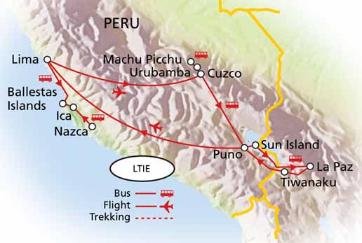
Nazca Lines and Cahuachi Culture
[Go to 11:28]
Stretching across the Nazca plains like a giant map or blueprint left by
ancient astronauts, lie the famous Nazca Lines of Peru. Peru is
associated with the Inca Civilization.
The Nazca Lines are an engima. No one has proof who built them or why.
Since their discovery, the Nazca Lines have inspired fantastic
explanations from ancient gods, a landing strip for returning aliens, a
celestial calendar created by the ancient Nazca civilization -- putting
the creation of the lines between 200 BC and 600 AD, used for rituals
probably related to astronomy, to confirm the ayllus or clans who made
up the population and to determine through ritual their economic
functions held up by reciprocity and redistribution, or a map of
underground water supplies.
There are also huge geoglyphs in Egypt, Malta, United States
(Mississippi and California), Chile, Bolivia and in other countries. But
the Nazca geoglyphs, because of their numbers, characteristics,
dimensions and cultural continuity, were made and remade throughout the
whole pre-hispanic period, forming a most impressive, as well as
enigmatic, archeological group.
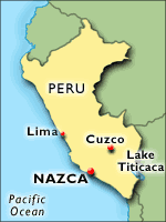
The Nazca Lines are located in the Nazca Desert, a high arid plateau
that stretches between the towns of Nazca and Palpa on the pampa (a
large flat area of southern Peru). The desolate plain of the Peruvian
coast which comprises the Pampas of San Jose (Jumana), Socos, El Ingenio
and others in the province of Nasca, is 400 Km. South of Lima, covers
an area of approximately 450 km2, of sandy desert as well as the slopes
of the contours of the Andes. They cover nearly 400 square miles of
desert. Etched in the surface of the desert pampa sand about 300 hundred
figures made of straight lines, geometric shapes most clearly visible
from the air.
The Nazca plain is virtually unique for its ability to preserve the
markings upon it, due to the combination of the climate (one of the
driest on Earth, with only twenty minutes of rainfall per year) and the
flat, stony ground which minimises the effect of the wind at ground
level. With no dust or sand to cover the plain, and little rain or wind
to erode it, lines drawn here tend to stay drawn. These factors,
combined with the existence of a lighter-colored subsoil beneath the
desert crust, provide a vast writing pad that is ideally suited to the
artist who wants to leave his mark for eternity.
The pebbles which cover the surface of the desert contain ferrous oxide.
The exposure of centuries has given them a dark patina. When the
gravel is removed, they contrast with the color underneath. In this way
the lines were drawn as furrows of a lighter color, even though in some
cases they became prints. In other cases, the stones defining the
lines and drawings form small lateral humps of different sizes. Some
drawings, especially the early ones, were made by removing the stones
and gravel from their contours and in this way the figures stood out in
high relief.
The concentration and juxtaposition of the lines and drawings leave no
doubt that they required intensive long-term labor as is demonstrated by
the stylistic continuity of the designs, which clearly correspond to
the different stages of cultural changes.
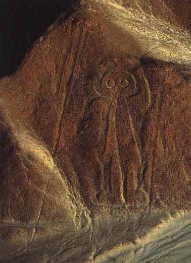
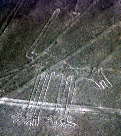
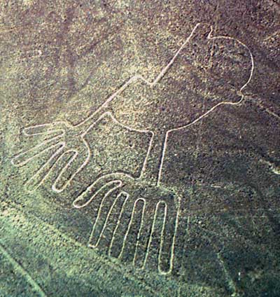
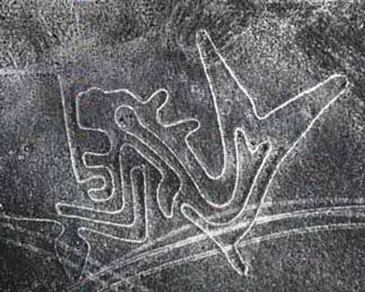
There appear to be various designs consisting of figures of animals,
flowers and plants, objects, and anthropomorphic figures of colossal
proportions made with well-defined lines. An example of this is the
drawing of a weird being with two enormous hands, one normal and the
other with only four fingers.
Also represented are drawings of man-made objects such as yarn, looms
and "tupus" (ornamental clasps). All these figures have well-defined
entrances which could be used as paths or to allow people to line
together along the conformations of the drawings.
The anthropomorphic figures are relatively few and are situated on the
slopes. The most well-known being is The Astronaut at 32m length
discovered by Eduardo Herran in 1982.
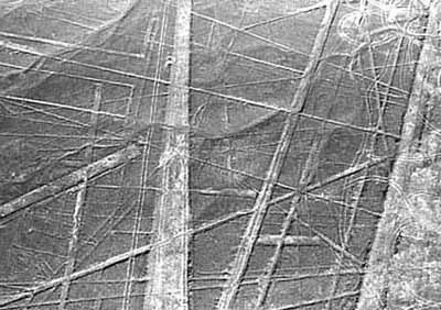
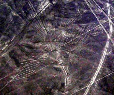
The lines are many kilometers long and crisscross sectors of the pampas
in all directions. Many of the lines form geometric figures: angles,
triangles, bunches, spirals, rectangles, wavy lines, concentric circles.
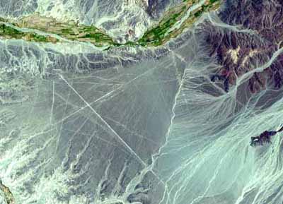
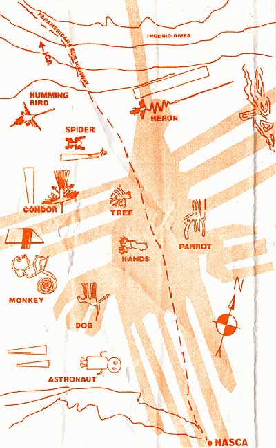
Satellite Image NASA
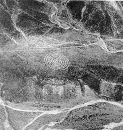
Spiral
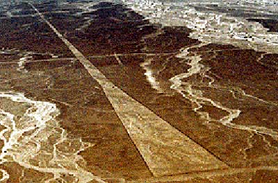
Trapezoid
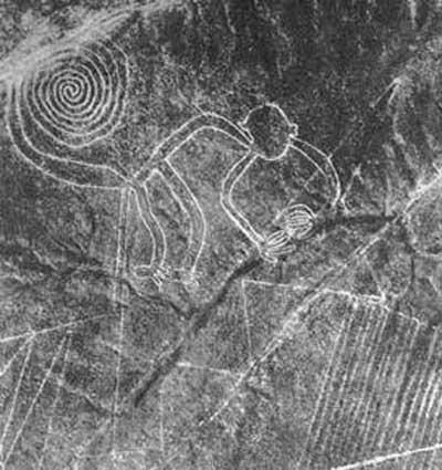
The Monkey (Biogenetic Experiments)
Dog? Four-legged Animals
Wing (Ascension of Consciousness)
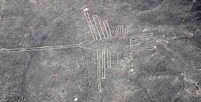
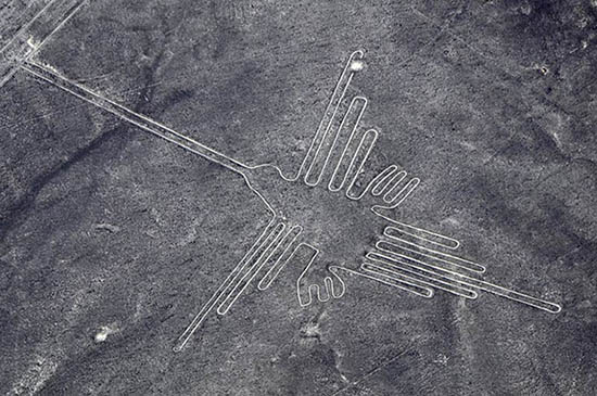
Hummingbird or Phoenix (Creation)
Condor
Whale
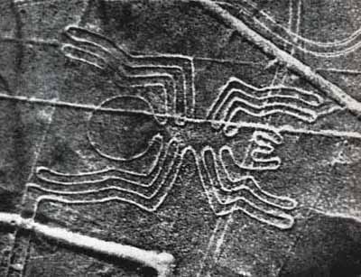
Spider - Spider Woman or Spiderweb Effect

Flower - Flower of Life?
Maps
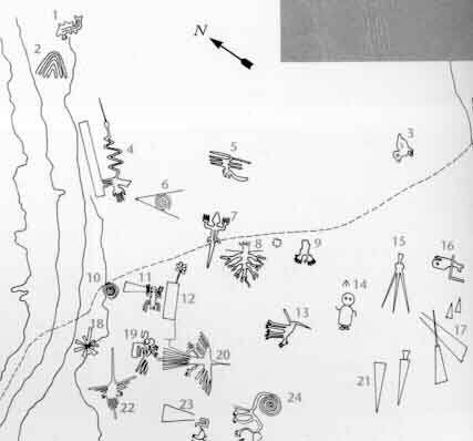
1. Killer Whale
2. Wing
3. Baby Condor
4. Bird
5. Animal
6. Spiral
7. Lizard
8. Tree
9. Hands
10. Spiral
11. Spider
12. Flower
13. Dog
14. Astronaut
15. Triangle
16. Whale
17. Trapazoids
18. Star
19. Pelican
20. Bird
21. Trapazoid
22. Hummingbird
23. Trapezoid
24. Monkey
25. Llama
26. Trapezoids
The Lines were allegedly made by removing the iron-oxide coated pebbles
which cover the surface of the desert. When the gravel is removed, they
contrast with the light color underneath. In this way the lines were
drawn as furrows of a lighter color. Off the Pampa, south of the Nazca
Lines, archaeologists have now uncovered the lost city of the
line-builders, Cahuachi. It was built nearly 2,000 years ago and
mysteriously abandoned 500 years later.
The Nazca Lines were first spotted when commercial airlines began flying
across the Peruvian desert in the 1920's. Passengers reported seeing
'primitive landing strips' on the ground below. Today people sometimes
fly in hot air balloons to view the splendors of the Nazca Lines, their
eneries awakening something within their souls.
It is difficult to keep the Nazca Lines free from outside intervention.
As with all ancient ruins, such as Machu Piccu, weather by wind and
rain, and human tampering will take their toll on these ancient Lines.
In recent years the Nazca Lines have suffered gradual destruction, as
tomb raiders seeking pre-Inca artifacts scar the terrain with hundreds
of burrows, garbage, among other waste material. A boom in copper and
gold mining - including a mine built in 1997 a few feet from a
2,000-year-old, two-mile-long trapezoid -- is defacing parts of the
Nazca Lines with tracks from truck traffic.
Over the past decade, advertisers and political campaigns have carved
huge messages in the rock and sand between the ancient designs in this
region 250 miles south of Lima.
In 1998, floods and mudslides from the El Nino weather pattern seriously eroded several figures.
As electricity reaches the growing local population, utility companies are running power cables over and around the site.
The damage to the Lines underscores Peru's desperate struggle to
preserve its national patrimony. Archaeologists say they are watching
helplessly as the quest for scholarship and conservation in a country
viewed as the cradle of New World civilization is losing out to
commercial interests, bleak poverty and the growing popularity of
heritage sites as tourist attractions.
=Toribio Mejia Xespe, a Peruvian doctor and anthropologist was the first
scientist, in 1927, to show interest in what he called "great Incan
ceremonial artifacts".
Michael Coe believes the Nazca Lines are sacred paths to walk by
specific rites. The primary lines were an offering for elders, heaven,
and mountain deities who gave them water for their fields.
Erich von Daniken suggested, in his 1968 book, Chariots of the Gods,
that the lines were built by ancient astronauts as a landing strip. But
the soft clay soil and layer of brown and black rocks in the Nazca
desert would seem an unsuitable site for landing and were blown away by
the power of rocket propulsion. The aliens left - never to return -
leaving the people confused. Like in the modern cargo cults they tried
to call the Gods back by drawing lines, figures and trapezes.
Robin Edgar beieved that the Nazca Figures were inspired by, and intended to be seen by, the (so-called) Eye of God that is manifested during total solar eclipses.
An extraordinary series of solar eclipses coincided with the
construction of the Nasca lines. Some Lines are aligned with the winter
solstice, a less spectacular but more regular, death and rebirth of the
Sun God.
The Code of Carl Munck - The Ancient Geomatria of Numbers --The Nazca Line ground markings locate themselves on The Code Matrix system. Nazca Lines and Archaeocryptography
The ancient sites around the world are very precisely positioned on a
global coordinate system in relation to the position of the Great
Pyramid at Giza. The positions of the sites are given in the geometry of
their construction. A very ancient system of numbers was used in the
system, which we will call Gematria. Gematrian numbers are found in
ancient myths and religions, including the Bible. Gematrian numbers were
used in systems of weights and measures by ancient peoples, including
the Greeks, the Egyptians, the Persians, the Babylonians and the Romans.
The Code system uses mathematical constants, such as pi and the
radian. The system also uses conventions that are still in use, such as
the 360 degree circle, 60 minute degree, 60 second minute, the base-ten
numbering system, the 12-inch foot, and the 5280-foot mile.
The ancient Mayans used Gematrian numbers in their very accurate timekeeping.
Maria Reiche was
a German mathematician and archaeologist who was famous for researching
the Nazca Lines. She believed the lines were an Astronomical Calendar
indicating the direction of the rising of important stars and planetary
events like sun solstices. Formations like the spider and the monkey
could show star constellations like Orion and Ursa Mayor. The problem
with all astronomical theories is the unknowing of the age. The
direction of stars changes within centuries, explained by the precession of the equinoxes.
Reiche led a determined effort to discredit theories of extraterrestrial
visitors. She argued that the Nazca Indians constructed the Lines some
time between 300 BC and AD 800. In support of this possibility, some
scientists have put forward ingenious ideas on how the geoglyphs could
theoretically have been designed from the ground. The more important
evidence, however, is that which attempts to link the Lines definitively
to the Nazcan culture. Here, neither of the two key pieces of evidence
survive close scrutiny.
The first piece of evidence is a series of radiocarbon dates, based on
ceramic and wood remains which were left at the Lines by the Nazca
people. It is claimed that this proves that the Nazcans constructed the
Lines. On the contrary, the dating of these materials tells us only that
the Nazcans lived in the area of the Nazca Lines. Since the Lines
themselves cannot be radiocarbon dated, the possibility remains that
they already existed when the Nazcan culture emerged. The second piece
of evidence is the alleged resemblance of the Nazca geoglyphs to certain
features found on Nazca pottery. This is an important issue because it
potentially offers proof that the Nazcans had either designed the images
or at least viewed them from the air. Maria Reiche died in 1998 at the
age of 95. She is buried in the arid valley she loved so well.
Professor Gerald Hawkins
and his group went to Nazca to prove the astronomical Theory of Maria
Reiche but was unsuccessful. In 1968, a study by the National
Geographic Society determined that, while some of the Nazca lines did
point to the positions of the Sun, Moon and certain stars two thousand
years ago, it was no more than could be expected by mere chance. In
1973, Dr Gerald Hawkins studied 186 lines with a computer program and
found that only 20 per cent had any astronomical orientation - again no
more than by pure chance.
Simone Waisbard stated that the drawing of Nazca are a giant
astronomical calendar. Further the Nazca-line-system was used to
measure the precipitation value. Figures, especially seabirds, have a
connection to the meteorological prophecy system of the Nazca-Culture.
Her ideas for the trapezoid formations: places for holy animals before
sacrifice them, or field claims connected with filter galleries,
observatories or places for ritual ceremonies of the different clans.
Alan F. Alford concluded that the Nazca-Lines was made by Negroid
Slaves of the Tihuanaco Culture. After a revolution the Negroid
population destroyed some figure, this is the explanation for overdrawn
zigzag-formations. Later this people went in northern direction and
founded Chavin and the Olmec culture.
Robert Bast linked the lines to the Flood Stories in his book A Memory of the Deluge. The animal, plant and human-shaped figures are lying together on the ground as a memorial place of the big flood.
Gilbert de Jong wrote A Nazcan Zodiac. He traveled to
Nazca and measured the GGF by GPS. He obtained a length of the square
side of about 54,7 Meter. In the formation he recognized a Zodiac.
Markus Reindel's Dowsing Theory
says that the Nazca Figures are markers for a subterranean waterflow.
Trapezoides show the broadness of the waterstream, zigzaglines show
where they end, lines show into direction of the puquitos. He explain
the nature of the figures by rod-dowsing (to find the subterranean
water) and shamanstic flights (to overview the figures).
 Nazca Lines Google Videos
 Nazca Culture - Cahuachi People
On the pampa, south of the Nazca Lines, archaeologists have now
uncovered the lost city of the line-builders, Cahuachi. It was built
nearly two thousand years ago and was mysteriously abandoned 500 years
later. New discoveries at Cahuachi are at last beginning to give us
insight into the Nazca people and to unravel the mystery of the Nasca
Lines.
In general, Nazca culture is considered to consist of three stages;
Early, Middle, and Late stages, and also the Classic Nazca
(approximately A.D. 250-750). One of the most famous and distinctive
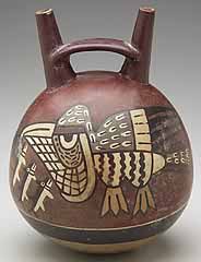
features of the Nazca culture is the polychrome pottery which has
attracted attention because of its technological refinement and the
exciting symbolism of its motifs. This pottery culture spreads in the
area of the valleys of Chincha, Pisco, Ica, Nazca and Acari.
In the Early stage, these wares did not have much color, but Middle and
Late Nazca polychromes are buff or red and are painted in three to eight
colors. The most popular choices of color were red, black, white,
brown, yellow, gray and violet with an outline in black. Bowls and
beakers were common forms, but double-spout and head-and-spout jars are
also found. Birds, fish or fruits were commonly drawn on the pottery,
and Nazca's religious or mythological features were also used in its
design.

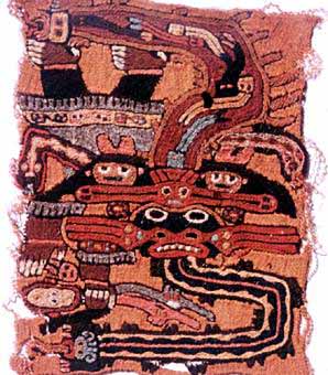
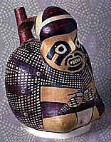
Nazca Figurine depicts a Solar Eclipse and the Eye of Creation
Cahuachi was a major ceremonial center of the Nazca culture and
overlooked some of the Nazca lines from 1 CE to about 500 CE. Italian
archaeologist Giuseppe Orefici has been excavating the site for the past
few decades, bringing a team down every year. The site contains over 40
mounds topped with adobe structures.
The permanent population was quite small, but it was apparently a
pilgrimage center that grew greatly in population for major ceremonial
events. These events probably involved the Nazca lines and the giant
sand dune of Nazca. Support for the pilgrimage theory comes from
archaeological evidence of sparse population at Cahuachi and from the
Nazca lines themselves which show creatures such as killer whales and
monkeys which were not present in the Nazca region. Trade or travel may
explain the images. Due to the dry climate the finds are quite rich and
include even such ephemeral material as clothing. Looting is the
greatest problem facing the site today.
Their ancient technique of weaving, that the Nazca people developed, has
given an insight into how the lines may have been made, and what they
might have been used for more than 1,500 years ago.
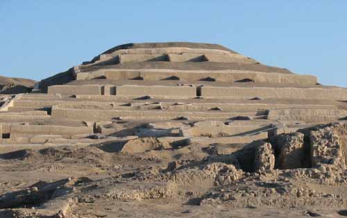
Cahuachi, in Peru,
was a major ceremonial center of the Nazca culture and overlooked some
of the Nazca lines from 1 CE to about 500 CE. Italian archaeologist
Giuseppe Orefici has been excavating the site for the past few decades,
bringing a team down every year. The site contains over 40 mounds topped
with adobe structures. It has also been studied by Helaine Silverman,
who has written a book on Cahuachi.
The permanent population was quite small, but it was apparently a
pilgrimage center that grew greatly in population for major ceremonial
events. These events probably involved the Nazca lines and the giant
sand dune of Nazca. Support for the pilgrimage theory comes from
archaeological evidence of sparse population at Cahuachi and from the
Nazca lines themselves which show creatures such as orca and monkeys
which were not present in the Nazca region. Of course, trade or travel
may explain the images. Due to the dry climate the finds are quite rich
and include even such ephemeral material as clothing.
Looting is the greatest problem facing the site today. Most of the
burial sites surrounding Cahuachi were not known until recently and so
present a very tempting target.
Most of the burial sites surrounding Cahuachi were not known until recently.
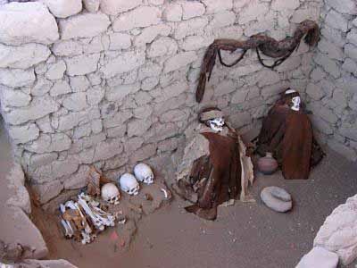
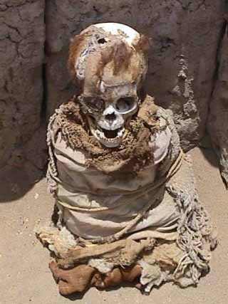
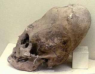
Stunningly preserved in the dry soil of the Peruvian desert
are the mummified bodies of the Nazca people themselves.
Articles in the News
Logging 'caused Nazca collapse' BBC - November 2, 2009
Forest clearances sealed ancient civilisation's downfall PhysOrg - November 2, 2009
Clearing oasis trees felled ancient Peru civilization New Scientist - November 2, 2009
Giant Figures in Peru Desert Pre-date Nazca Lines
Nazca Fisherman
The Epoch Times, May 24, 2005
A group of about 50 drawings of giant figures recently discovered in the
hills of Peru's southern coastal desert near the city of Palpa has been
said to predate the famous Nazca lines nearby.
Mr. Johny Isla, director of the Andean Institute of Archaeological
Studies, said the 'geoglyph' figures appear to have been created by the
Paracas communities between 500 and 400 BC, whereas the Nazca culture
developed after 50 BC.
Mr. Isla and his partner Dr. Markus Reindel from the Dutch Institute of
Archaeology discovered the Paracas figures using aerial photography and
land-based surveys. The figures of humans, birds, monkeys and cats vary
in size from 10m to 50m across, and are also grouped together in areas
up to 60 m to 90 m across.
The Paracas figures were created by removing dark stones in order to
expose the lighter surface underneath. Some areas were cleared and
others built up with rock, creating figures in high and low relief. With
the Nazca lines though, the geoglyphs were only made by clearing
low-relief areas. Until recently scientists believed that the figures in
the Palpa and Nazca regions were only from the Nazca culture. Mr. Isla
says cultural dating and style of the newly found Paracas figures sets
them apart.
Mr. Isla told The Epoch Times, "Most of these geoglyphs belong to the
Nazca culture but our recent studies demonstrated that there are at
least 50 geoglyphs pertaining to the Paracas culture. These new figures
are definitely different and older than those of the Nazca culture.
- First, the Paracas figures were drawn on the slopes of the hills, while the Nazca images were drawn in level areas.
- Second, the Paracas figures are smaller and were made in a naturalistic style, while the Nazca figures are bigger and stylized.
- Third, the Paracas figures are mostly arranged in groups, while the Nazca figures are arranged individually.
- Finally, it is important to note that not one of the Paracas figures were repeated in the Nazca iconography."


0 comments:
Post a Comment